New-fangled terms like smart agriculture, big data and precision farming have roared into the industry’s consciousness in the last couple of years, and nowadays pioneering companies are taking elements of this and adapting it to their businesses.
While the expanding role of robots is the big talking point in packhouses and glasshouses, out in the field, new technology is giving agronomists unparalleled depth to their soil and crop analytical capabilities.
One group which is putting a particular focus on remote sensing technology for monitoring canopy growth is a new Agri-Tech East Special Interest Group, co-chaired by Dr Toby Waine, a lecturer in applied remote sensing from Cranfield University.
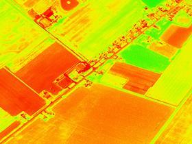
Waine’s group aims to create a roadmap for directing technology development in this area, with a particular focus on the evolution of drone technology for canopy cover monitoring. Where previously canopy visualisation was a laborious manual task, now, camera-mounted drones are making the process digitalised and far more valuable.
Special cameras can monitor infra-red wavelengths, which can be used to calculate vegetation indices to determine the photosynthetic action of the crop, as well as give early warnings of disease.
And Waine believes we are at the tip of the iceberg of what can be achieved. “The challenge is to detect small differences at a very early change,” he explains. “These changes are incredibly difficult to monitor from aerial platforms due to the mixture of light reflected from crop leaves, soil and shadows. However, as the spatial resolution of the cameras improve, giving more control in the selection of wavebands in sensors, this will become a reality. Being able to detect diseases earlier, even by a few days, will reduce the spread of disease and plant protection required.”
One company that is already using drones to monitor its potato crops is Branston. The supplier initially worked with Leicester University to understand how it could use satellite imagery for agronomy, and in particular the monitoring of yield, crop variation and crop growth, and the next step was the use of drones.
“We now have our own drone which we fly over our fields at different intervals to understand the crop growth,” says Branston’s innovation director Vidyanath Gururajan.
Part of the challenge with drones, explains Gururajan, is the time and expertise needed to compute and analyse the vast amount of data it picks up. There are also issues around cost and the number of different cameras required on the drones to get the full set of information.
To give a holistic picture, Branston is planning to combine drones with satellite and field-sensing technology to give it a deeper level of crop
intelligence.
The company is also sitting on a UAV special interest group in Harper Adams’ Precision Engineering department to share knowledge and encourage the industry to embrace this new technology.
Produce World, meanwhile, is taking aerial technology a stage further. The potato and vegetable giant is working with former RAF pilot David Wright of Spectrum Aviation to send up a manned Sky Arrow aircraft kitted out with up to five sensors – drones typically only carry one – to analyse the grower’s crops.
According to Produce World’s research head Guy Thallon, drone technology proved limited and expensive, and the Spectrum Aviation option gives greater visibility at a much lower cost.
On-board options include standard RGB or hi-fi cameras, with the ability to zoom into an individual plant just like a farmer could if he were walking through the field. There are plans to upgrade the cameras to a multi-spectral array that can produce a wavelength plan and vegetation indices for much more precise modelling and analysis. Crucially, it has the capability for the early spotting of diseases, allowing a targeted agronomic response.
The technology allows more precise yield analysis and forecasting, which could give growers a critical advantage in the often challenging potato and field veg sector.
But isn’t all this prohibitively expensive? Wright claims it is actually massively more cost effective than drones. He currently estimates it costs £5/ha, but if he is covering 1,000ha in an hour the costs come down significantly – he believes £1-2/ha is not out of the question in the longer term.
The drone wars may have started, but they are only the opening shots in a new era of data gathering in which technology will take centre stage in ensuring growers have the best possible tools in their agronomic arsenal.
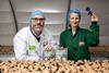
Branston's smart potato
Branston uses a range of technology to ensure it handles potatoes as gently as possible. One tool is the electronic potato, which helps the firm understand the effects of washing and handling on the crop.
The device, which looks like a potato but has electronic sensors inside, is able to monitor the impact as a potato moves through the packing process and comes into contact with different surfaces. It means that adjustments can be made to the lines to reduce the likelihood of bruising and internal damage. “Making good use of this technology has the benefit of reducing rejections down the supply chain,” says Gururajan.