An online map showing soil types across England and Wales has been launched by aerial mapping company Bluesky and Cranfield University.
The National Soil Map has been created from soil datasets produced by Cranfield's Soil and Agrifood Institute (CSAI) and isdesigned to inform decision making in a wide range of applications, from land and infrastructure management to construction, habitat assessment and agriculture.
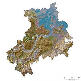
The map combines Cranfield’s NATMAPvector soil dataset, which lists almost 300 soil associations, with the more simplified Soilscapes product.
Many growers, particularly in potatoes and field vegetables, are now using drones and aerial mapping technologies to analyse the state of their fields and the quality of soil.
“If you want to better manage your land, buildings, infrastructure or environment, understanding the soil is a great place to start,' said Dr Timothy Farewell, senior research fellow at CSAI. 'Soil is a fundamental building block for our ecosystem, and provides key support for, and threats to, our infrastructure and buildings.
“The source data for the Bluesky version of the National Soil Map is the result of more than 60 years of soil survey work and took over 200 man years to create. Our soil data is already in use by most major water companies, many consultants and government bodies.”
Rachel Tidmarsh, managing director of Bluesky, added: “This is the first time a dataset of this nature and complexity has been available to view and purchase online, and we are delighted to be working with Cranfield to ensure its wider application across a range of sectors.'